


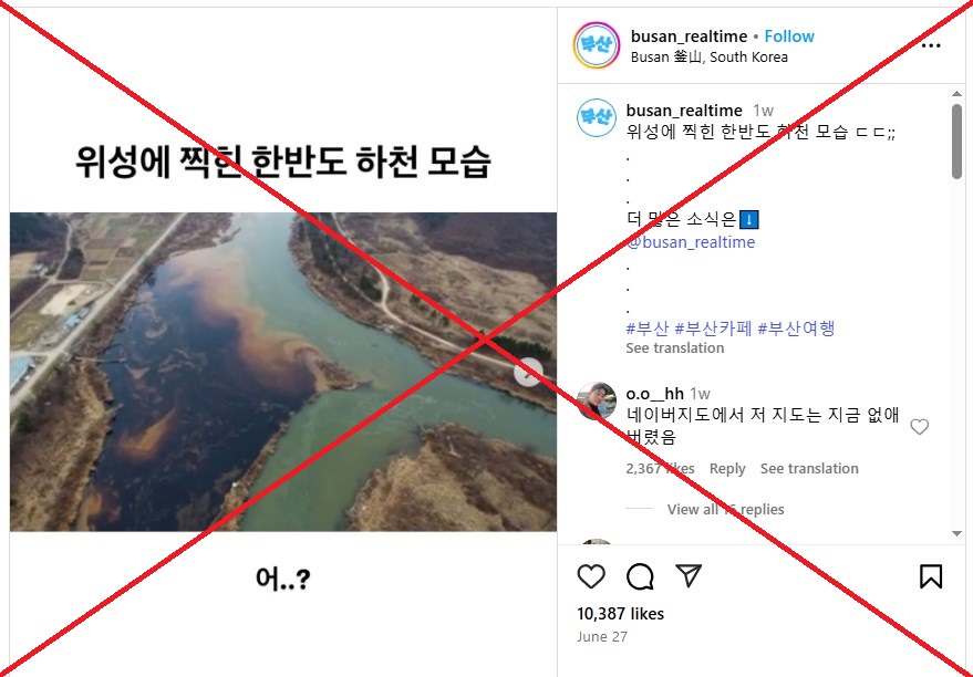


"A river in the Korean peninsula captured by satellite," reads Korean-language text superimposed on an image shared on Instagram on June 27, 2025.
The image appears to show an aerial view of an iridescent oil-like slick where one river meets another.
A separate image, an annotated map, attached to the same Instagram post indicates the satellite imagery was taken from where the Ryesong River from the North meets the South's Han River and the sea.
It surfaced days after Daily NK, an online media outlet run mostly by North Korean defectors, reported that Pyongyang was secretly discharging uranium-processing wastewater into rivers flowing into South Korea (archived link).
The report did not include any photos of the supposed contamination.

Screenshot of the false Instagram post captured July 4, 2025, with a red X added by AFP
The same image was also shared in similar posts on Facebook, TikTok, YouTube and online forums.
Some posts criticised the administration of new President Lee Jae-myung, accusing it of failing to hold Pyongyang accountable while his party previously protested Japan's release of treated wastewater from the Fukushima nuclear plant in 2023 (archived link).
"How can the government just watch this happen and not say a single word," read a comment on one post.
Another said: "I'm not going anywhere near rivers near the west coast."
But there have been no official reports or photos of radioactive contamination published by either the South Korean authorities or local media.
'Made with Google AI'While a reverse image search led to more posts using the same picture, Google's "About this image" feature identified it as having been made with AI.
The ability to detect AI-generated images is based on Google's SynthID technology, which was launched by its DeepMind AI lab in 2023 (archived here and here).

Screenshot of Google page indicating the circulating image was made using AI
The image also differs from Google Maps imagery of where the Ryesong River meets the Han River, with the landscape, shoreline and surrounding features failing to match (archived link).

Comparison between AI image (left) and the Google Maps imagery of the area between the two Koreas (right), with the North's Ryesong River highlighted by AFP
'No possibility'A spokesperson for South Korea's Ministry of Environment told AFP they could not determine which river is supposedly shown in the circulating image.
"But there is no possibility that a North Korean discharge would contaminate South Korean rivers," the official said during a phone interview on July 7, explaining that the water systems do not flow in a way that would carry such discharges upstream.
The Han River, which runs through Seoul, originates from the Taebaek mountain range in the east and flows towards the Yellow Sea in the west, according to data published by the Japanese space agency's Space Technology Directorate (archived link).
The environment ministry spokesperson also stressed the image itself does not constitute evidence of nuclear contamination.
"The image appears baseless and does not show anything we can identify as contamination caused by nuclear wastewater."
The spokesperson said the ministry is conducting an investigation with other agencies into wastewater discharged from North Korea’s Pyongsan uranium plant, and is working with the Nuclear Safety and Security Commission to test water and sediment samples for traces of uranium and other radioactive materials (archived link).
"That investigation concerns the sea, however, not inland rivers," they said. "There is no reason to believe South Korean rivers have been contaminated."