


BBC News
Darren BettLead Weather presenter
Watch: Risk of storms as hot temperatures start to peak
The hottest day of the year so far has been recorded in the UK, as a Met Office warning for thunderstorms comes into force.
A temperature of 33.2C was recorded on Saturday afternoon in Charlwood, near Gatwick, beating the previous 2025 record set earlier this week.
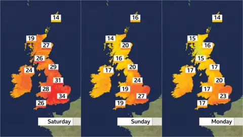
Saturday is expected to be the peak of the recent hot weather, with temperatures expected to dip into Sunday.
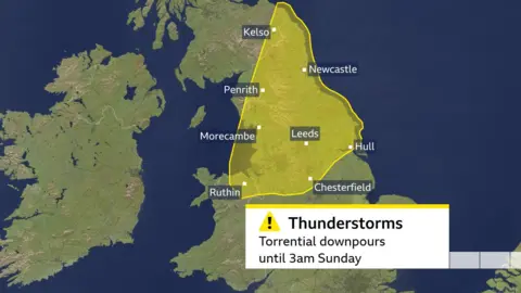
The yellow weather warning is in place until 03:00 BST on Sunday for parts of northern England, the Scottish Borders, and north-east Wales.
Storms are expected because the humid weather means there is plenty of moisture in unstable atmospheric conditions. They could bring localised flash flooding, large hail, and lightning.
An amber heat-health alert in England issued by the UK Health Security Agency remains in force until Monday, as fresh research suggests nearly 600 people could die in the next four days because of the heat in England and Wales.
Researchers at the London School of Hygiene and Tropical Medicine and Imperial College London predict that there could be around 570 heat-related deaths, using decades of UK data, with the greatest number, 129, in London.
Prof Antonio Gasparrini, of the LSHTM, said: "Every fraction of a degree of warming will cause more hospital admissions and heat deaths, putting more strain on the NHS."
Passengers were forced to evacuate a train in south London on Saturday as temperatures reached more than 30C in the capital.
A fault on a train near Loughborough Junction brought all services in the area to a halt, three of them outside station platforms, Thameslink and Network Rail said in a joint statement.
It apologised to affected passengers and said that "without power and air conditioning on such a hot day" it pulled resources from Sussex and Kent "to get personnel on site to safely evacuate passengers as quickly as possible along the track".
By Friday afternoon, many regions met the criteria for a heatwave - meaning a temperature threshold was sustained for three consecutive days.
The threshold varies across different regions, from 25C in northern and western parts of the UK to 28C in south-eastern England. Suffolk became the first area to officially enter a heatwave on Thursday, when temperatures surpassed 27C for a third day.

Humidity has also been increasing, making the heat feel more uncomfortable, particularly at night.
On Saturday night, as cooler and fresher air pushes in from the west, the highest overnight temperatures will be restricted to eastern England, where they may fall no lower than 18C.
While heatwave conditions are likely to continue, some relief is anticipated on Sunday, when the south and east of England will dip to the high 20s. Elsewhere, cooler air will gradually sweep in from the west.
Temperatures will drop further into Monday - but could rise towards the heatwave threshold again in the latter half of next week.
 BBC Weather Watchers/Helen Earth
An area of high pressure is helping to draw the hot weather in
Firefighters in England and Wales have already responded to more than 550 wildfires across England and Wales so far this year - a 717% surge on the same period in 2024, the National Fire Chiefs Council said.
The association's chairman Phil Garrigan said it was "deeply concerned about the escalating threat of wildfires this summer", which he warned have "the potential to become more frequent, intense and dangerous".
The organisation is urging the public to be careful when lighting barbecues and handling objects, such as glass bottles, that can cause a fire outside.
There are currently no hosepipe bans in place, despite the Environment Agency warning water firms at the start of May that action would need to be taken to safeguard water supplies over the coming months.
This is because, while reservoir levels are relatively healthy, a very dry spring means there is a medium risk of drought.
While linking climate change with specific individual extreme weather events can be difficult, scientists say that climate change is generally making heatwaves hotter and longer.
The World Weather Attribution group says that the chance of reaching 32C in June has increased by 100 times since the pre-industrial era.
The chance of a three-day June heatwave had increased tenfold due to human-induced climate change, going from a one-in-50-year event to a one-in-five-year event.
Ben Clarke, a researcher at the Centre for Environmental Policy at Imperial College London, said that with "every fraction of a degree of warming, the UK will experience hotter, more dangerous heatwaves".
He added: "This means more heat deaths, more pressure on the NHS, more transport disruptions, tougher work conditions and poorer air quality."
Watch: UK crowds celebrate summer solstice on Saturday
Meanwhile, people across the UK made the most of the early morning sun on Saturday to celebrate the summer solstice - the longest day of the year - at sites such as Stonehenge and Glastonbury Tor.
Originally a pagan tradition tied to agriculture, marking the solstice now has broad appeal.
"It's just lovely breathing points throughout the year," Morris dancer Grace told the BBC at Avebury henge, a neolithic stone circle in Wiltshire. "The sun stands still and it gives you a chance to stand still."
Matthew Watkins, a Cardiff resident, described seeing the sun rise over Avebury as "glorious" and "a special moment".
Additional reporting by Sophie Parker and Adam Clerck

Get our flagship newsletter with all the headlines you need to start the day. Sign up here.